..........--- Hard to Sail with no Wind --
.....................................................--- and ---
....--- Trip to Cayo Costa State Park --
.--- Mon./Tues. - Nov. 29th and 30th---
Day's Starting and Stopping Points:
Today's Starting Waypoint = 026°41.160 N -- 082°14.384 W
Today's Ending Waypoint = 026°41.160 N -- 082°14.384 W
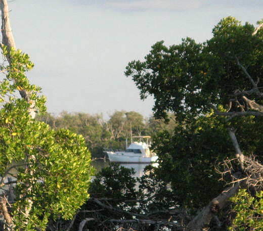
Night's Anchorage: Smaller bay on the east side of Pelican Bay
Anchorage = 026°41.160 N -- 082°14.384 W
Monday, the day after arriving at Pelican Bay we headed out with hopes of sailing some.
........
We reversed our route into the bay and head out towards the lower end of Charlotte Harbor passing the sand beach on the northwest side of the bay.
........
At the mouth of the bay we head towards marker #74 on the Inter coastal Waterway about a third of a mile out past the entrance to the bay. If you are headed to Pelican Bay go to marker #74 and then enter the bay very close to the beach on the north side. It is shallow on the south side of the entrance.
........
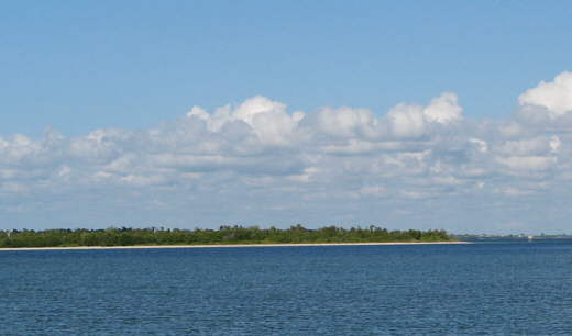
To the north a couple miles in the distance was the south end of Boca Grande. The entrance, cut, from the Gulf into Charlotte Harbor is between Cayo Costa and Pelican Bay and Boca Grande. Once out into Charlotte Harbor you can look back through the cut to the Gulf.
Our destination was the area of Charlotte Harbor to the north and east of marker #74. There is a lot of deeper water there. In this part of the world 'deep' is over 10 feet and the charts show the depths in that area ranging from 10 to 16 feet deep.
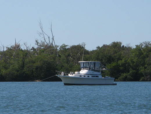
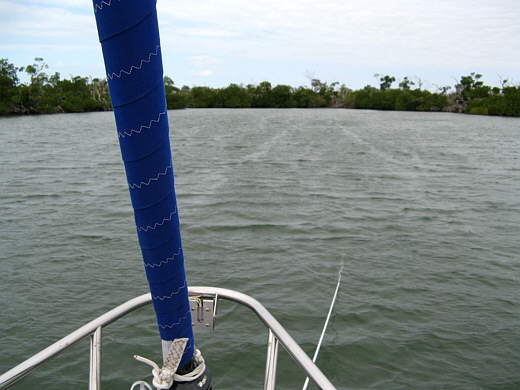
Where as there was plenty of wind the day before to sail there wasn't much at all on this day. We pretty much just floated around and relaxed between brief, very brief, spells of winds under 5 mph. A couple sailboats went by under power and sail, but due to the low winds there weren't many boats out except for some power boats.
We fixed a couple ham wraps, what we called ham, cheese, and mayo and pickles wrapped in a tortilla. On this trip we decide that bread was probably going to mold on us pretty quickly, and that tortillas would last a lot longer, so stocked up on those and enjoyed them a lot. After lunch and still no wind we fired the outboard up late in the afternoon and headed back and anchored very close to where we had been before.
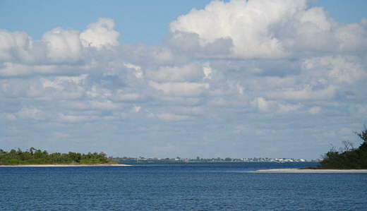
The weekend was over and now we just shared the rather large bay with just a couple other sailboats and a cruiser. Using the onboard long range WiFi I was able to hook up to a marina that was up at Boca Grande at least 2 1/2 miles away and it might of been 4-5 miles away. I was impressed with the power of the Bullet 2HP radio up on the antenna. This was the first time I could connect as when we had been over in the fresh water canal system a couple miles from where we launched we were too remote to any businesses or houses and there were a lot of trees there. After spending some time on the Internet and seeing that the next day was suppose to be nice we decided to go over to Cayo Costa State Park the next day and walking over to the Gulf Side of the island.
Tuesday morning was another good morning on the water. We took our time getting up and eating breakfast and messing around on the boat a little. It is surprising how much of you day goes by just eating, moving stuff around, and taking care of small odds and ends.
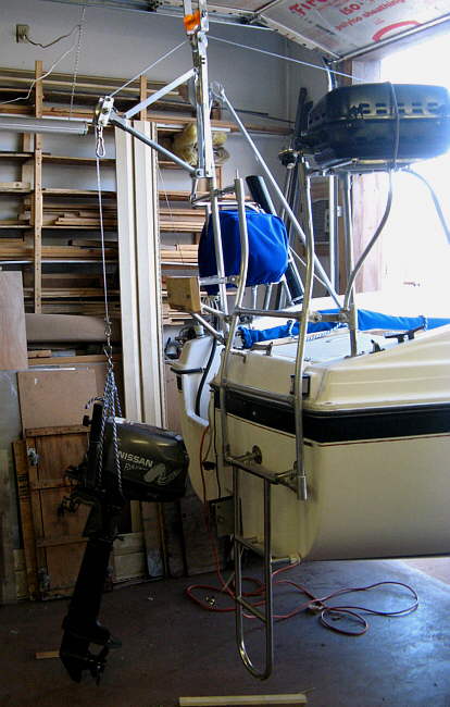
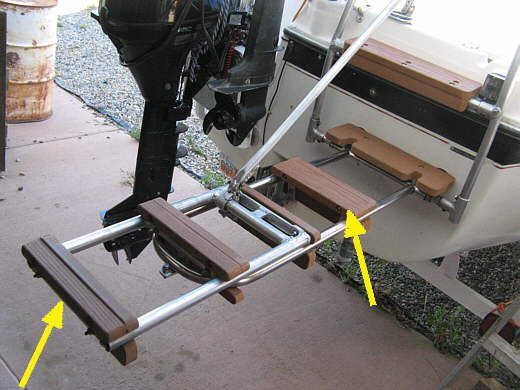
I took the dinghy outboard, a 5 HP Nissan long shaft, off of its mount on the stern of the Mac and put it down into the Zodiac. I'd considered using....
........
... the outboard hoist I had made, but decided to just try lifting the 60 lb. outboard off and trying to put it down inside the dinghy. I was able to do it, but only by standing on the......
........
...... boarding ladder with it in its horizontal position and then without a whole lot of confidence that I wouldn't slip or something and send it to the bottom. I probably won't ever do that again without at least a safety line on the outboard. In fact in the spring of 2011 we plan on getting a lighter 40 lb. 3 1/2 Tohatsu long shaft to use on the dinghy and as a backup for the Mac. We will be much more likely to use the dinghy more to explore if getting the outboard on and off is easier on this old man who is only getting older. I don't like towing the dinghy with the outboard on the transom........
........
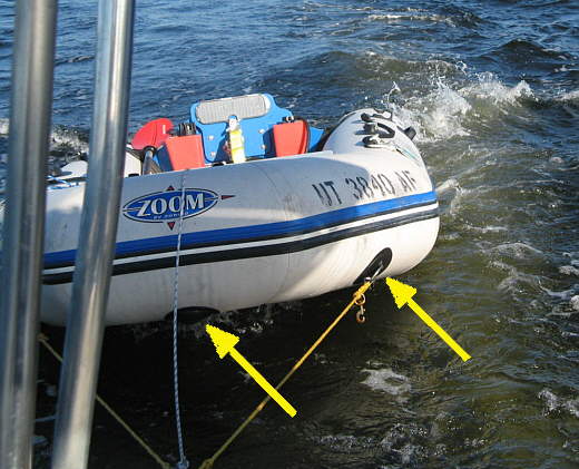
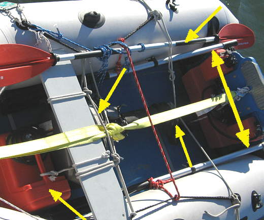
....... so made up a new tow strap arrangement that is much better if we do that. We had never had any problems pulling the dinghy, but if the outboard was on it while being towed the bow was quite high. You can see the reason for it above. We were pulling the dinghy with the bow rings (right arrow) on it and they tend to lift the dinghy up as shown in the picture. The center line in the picture (left) arrow is just a secondary line in case the other line was to break.
I felt a possible solution was to pull the dinghy from the transom instead of the bow. When we went back ashore the first day and went and dumped our trash we stopped at a Walmart......
........
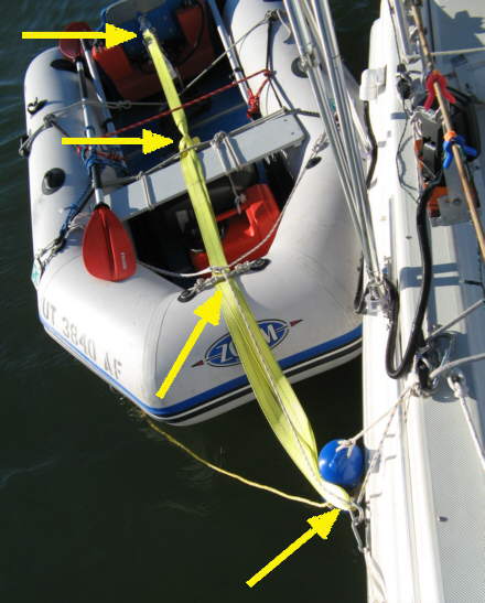
.... and bought the yellow tow strap above. I left the hook on one end and then cut the strap shorter, but long enough to go from the transom (top arrow) out and over the bow up to the carabiner (bottom arrow) that the original tow straps attach to and then back into the boat about where the seat is (second arrow from the top) and tied it back on itself there.
At night we leave the tow lines attached, but pull the Zodiac up along side and clip a short line that is attached to the lifeline stanchion on the starboard side and has a carabiner on it onto the carabiner on the tow line (bottom right arrow) and then I lower a small blue fender over the side at the same point. The Fender helps to keep the noise from the carabiners down during the night when they tend to click against the side of the Mac.
I added the lines at the bow (2nd arrow up from the bottom) to position the strap there also.
........
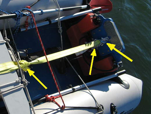
At the back of the boat (right arrow) I had a line tied from the transom down to the fuel tank (middle arrow). It is there to avoid loosing the tank out of the boat like what happened on the incident at Lake Powell.
I hooked the tow strap hook to that line (right arrow). When using the dinghy you just have to unhook the hook and place the strap inside at the bow of the boat. The left arrow points to where I tied the strap back on itself. Tension on the strap can be set by where this knot is tied.
........
Here is a picture with the 5 HP Nissan tied in the boat under the seat (top left arrow). The lower unit and prop is also tied to keep it in the middle (bottom right arrow). I also placed the dinghy oars (double sided right arrow) along the sides to protect the sides just in case the outboard shifted. I don't use them much as the dinghy doesn't row that well. Usually I sit on the bow seat and use the kayak paddle (top right arrow) to paddle from the bow. This works well. Also note that all of the oars/paddle are tied in to avoid loosing them.
........
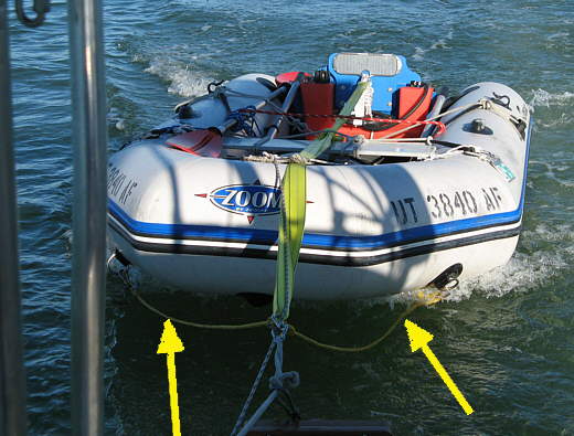
Look how much flatter the dinghy now rides in the water and the bow lines are now slack (arrows), so the transom is now taking the strain from the pull and that is pretty considerable if you ever try and hold the tow line while underway.
........
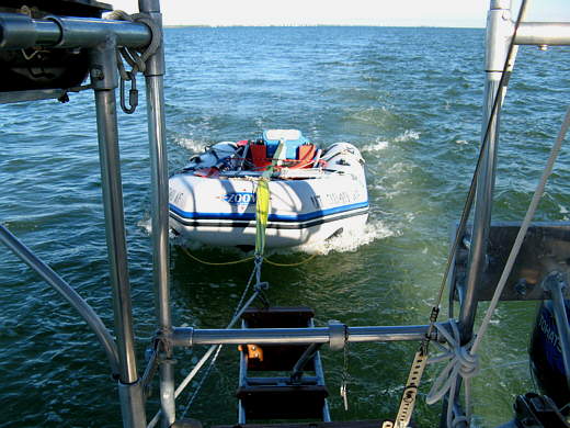
We didn't try it with the outboard in the dinghy, but it was on the floor in there while these pictures were taken. I'm really happy with how easy this mod was and how well it has worked pulling the boat to this point (75 miles).
Back to the trip.....
========================================================
Well finally right after lunch we motored over about ....
........
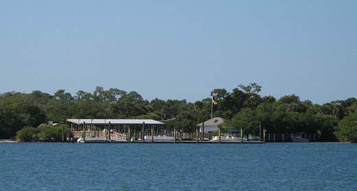
...a third of a mile to the dock at the state park. I don't have a clue how it happened, but when we were just about to the dock I hear this very loud ship's horn go off. I was crossing right in front of a 2 deck passenger ferry coming into the dock also. I was clearly in the wrong and I still can't believe that I got so focused on where I was going that I didn't look around better. Note to self, stay more alert on the water. I quickly turned to starboard and they passed in front of us and we went behind them to a small dinghy dock on the north side of the main dock.There were two other dinghy's there and we tied off between them and went ashore. It was the first time either of us had been off the boat in 5 days and we were a little shaky on our feet at first.
Now for the second or third dumb move of the day....we both forgot our cameras, so google Cayo Costa State Park and see what a beautiful place it is.
First for a link the the state park and info about it click ( HERE ).
First thing first was using the bathrooms, then it was over a hundred yards or so to register and pay our $2.00 each entrance fee. Then it was on to the other side of the island about .9 of a mile away. They have a tram service which consists of either a pickup or something that is like a golf cart pulling some open wheeled passenger wagons. I think it goes about once an hour and you can take it both ways or one way in either direction and there is no charge.
Since we usually walk about 2 miles daily at home and hadn't walked at all for 5 days we decided to walk. Did I mention we also hadn't brought water. I think they sold it at the park building, but we loaded up at the drinking fountain. There are trails going to the other side and also the north side. They are one lane dirt just wide enough for them to take a vehicle down. We enjoyed the walk to the other side as almost all of the vegetation we saw was new to us. They had a few signs telling you what something was if you could tell which plant they were talking about.
When we reached the beach on the other side we were the only ones where the trail ended. There was a boat and some people a couple hundred yards away to the north. We took our shoes off and waded in up to our knees. I was amazed as to how flat the water was with just very small waves. I've been to the beaches in the northeast, west coast, Hawaii and Mexico and I've never seen such flat water at an ocean. I wish it would of been warmer. I would of like to have seen what it was like going out in it, but we are both at the point where we need 80+ degree water to survive.
We were very content you just sit in the sand and watch the hundreds of birds that were feeding at waters edge or out in the Gulf itself. A beautiful place and a great destination. As the afternoon wore on we started walking a short ways north in order to walk a little longer trail back over to the east side of the island. Along the first part are some small older cabins that you can pay for by the night (again check the park site for info). After the cabins the trail took a windier route east and back to the far side of the island. This trail is a little more close in that the other as the tram doesn't use it. Again the fauna was intriguing to us westerners.
Back at the headquarters we waited for the person there to come back from doing the tram run so that we could go in and buy a couple souvenirs. Ruth got a couple insulated cup holders, probably made in China, and I settled for a candy bar. Exciting huh?
Then it was down to the dinghy which we were pleasantly pleased to find was still there along with our dinghy bag inside of it. I decided that we would start using a different duffle type bag that we could run a bike cable lock through that would lock the top and lock the bag to the dinghy in the future since it has cloths and all of our coast guard required stuff and sometimes a handheld VHF. Also I thought I would start taking the emergency red outboard shutoff key with us to make it a little harder to start the outboard and keep it running. We haven't dinghied to shore much in the past in the west, but we could see doing more of this in the east and I guess we need to not be quite as trusting as we have in the past.
On our way back to the boat in the dinghy we...
........
..... passed this cruiser and....
........
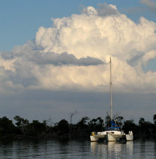
...this pretty trimaran was anchored close by, but unlike the weekend the bay was pretty empty.
Just past the trimaran was....
........
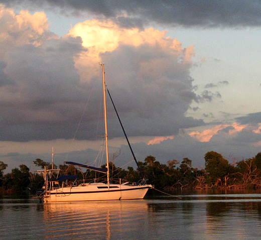
....our Kera-Jane.
The predicted wind speeds were suppose to go up into the 20's or low 30's during the night and be out of the northwest. That direction had the most open water coming in on us, so we decided to move the boat from where we had been anchored to......
........
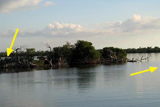
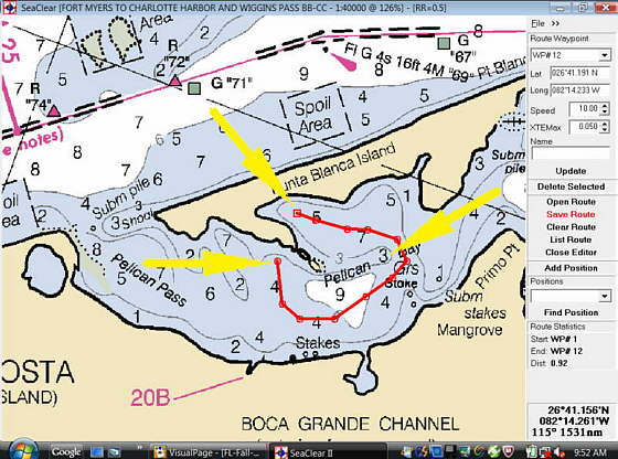
a smaller bay just a couple hundred yards to the east (left arrow). To move the couple hundred yards east involved about a 3/4 mile trip in the direction of the right arrow to avoid some shoals (see the chart at the bottom of this page) .
........
This view is from our first anchorage across the spit of land to where we went and to the left of the boat in the picture above that had anchored over there the day before, but was gone when we went over.
........
We anchored near the end of the small bay with quite a little more rode out (notice the shallow angle of the line) than normal due to the expected winds. We had enough out that if we swung to port or starboard we would be close to the shores there.........
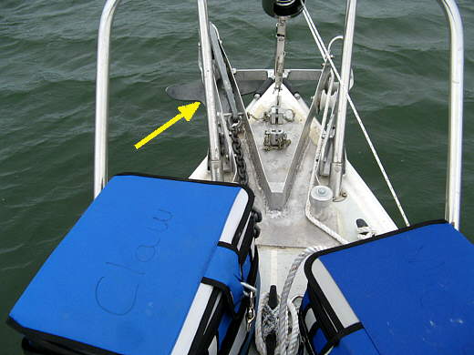
Up to this point we had never used the new 25 lb. Manson Supreme anchor, but decided to use it with the prospect of increased wind speeds and left the claw (arrow) on the other roller. The rest of the trip we usually used the Supreme most nights along with the claw on some occasions.
We also tried out...
........
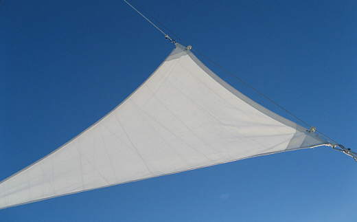
...Ruth's anchor sail out for the first time (shown above on a different day). The sail worked well, but with a couple reservations.
When we got the kit from Sailrite for Ruth to sew up they said to tie the clew at the left in the picture above off to one side of the boat vs. tying the clew to the mast and the centerline of the boat like a wind vane. This gets the boat sailing off to one side a bit and it pretty much then stays there, kind of like "heaving to". This works pretty well, but the boat still swings some and sometimes the sail will be filled like above when the wind will change slightly or the swing will make the sail so slack, like in the "irons", and the sail will fill out from the other side and swing a ways and go slack and refill from the dominate side. When this happens in heavy winds over 20 mph the sail really bangs and the boat will kind of shutter as it fills from one side or another. This filling from side to side is not a constant thing, but it does happen.
This is especially disconcerting in the dark in the middle of the night when you are sleeping and every sound sounds worst than it is. I'm also not sure if the resulting forces are good on the rigging. After enduring this on the first night with winds over 20 mph and another night like it we decided if the wind was going to be that heavy we wouldn't fly it and would just put up with swinging on anchor. I didn't try tying the clew to the centerline of the boat, but can see where it would then be constantly filling side to side with a bang. If the anchor sail was a fixed flat plane line a wind vane then I can see it working, but it isn't and needs to fill with air to work.
We do plan on still using it and we could tell by boats near us that we weren't swinging near as much as they were. Also the next trip I'm going to try running it lower on the backstay and see how that works. I'll report back on that on the page where Ruth made the sail ( HERE ).
........
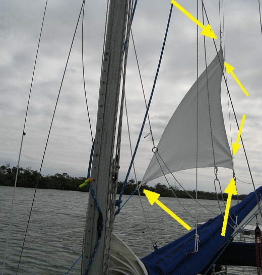
The sail hanks on to the backstay (2 smaller right middle arrows). The head is attached to a 1/4 inch halyard that goes up to a double block on the chicken head at the top of the mast. The topping lift also runs up to the same block. The clew (bottom left arrow) is attached to a line that goes forward, more on that in a moment and the tack is attached (bottom right arrow) to....
........
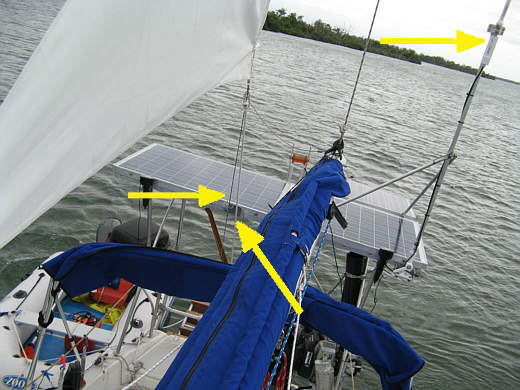
... a line (bottom right arrow) that parallels the backstay (bottom left arrow) and runs in front of the solar panes down to the stern. The top right arrow points to the long range Bullet 2HP WiFi radio at the base of the WiFi antenna.
........
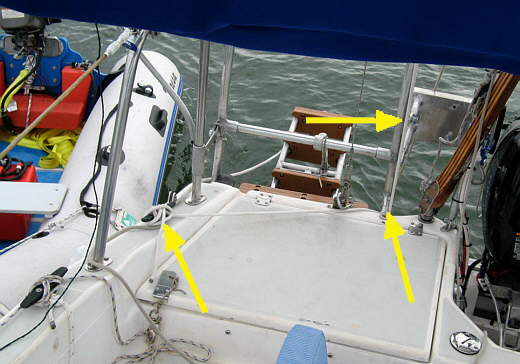
Here you can see the line coming down (top arrow) from the tack. It just goes around a support for the stern ladder (bottom right arrow) and over to a cleat on the starboard side where it is cleated off.
........
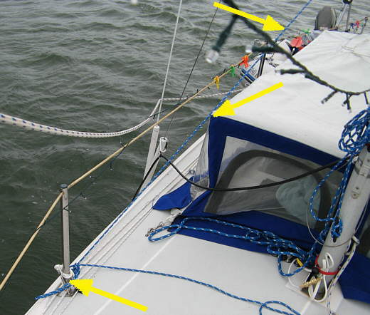
The line from the clew (top arrow) goes down to and is tied off to the forward lifeline stanchion (bottom left arrow). This worked good except the first night the line ran right at the corner of the pop-top (middle arrow) and when the sail filled from side to side the line would move from ones side of the corner to the other with a pop. Loud enough that it awoke me and I had to go up in the dark to see what was going on. After that I repositioned the line slightly so that it wasn't rubbing on the corner of the pop-top.
We like that anchor sail and it goes up very quickly. When it is down I wrap the tack line and clew line around it. To set it you just hank it on with the 2 hanks and hook the uphaul line to it and tie the downhaul line where you want the bottom of the sail to be and pull on the uphaul line and cleat that off on the mast (I added a cleat for it) and then tie the clew line off. A couple minute operation and it even comes down quicker. It isn't large, so storage is not a problem. I'd recommend one to anyone that spends a lot of time anchoring out.
........
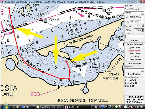
Above was our route into and out of Pelican Bay to the ICW marker 74 (top left arrow). Use this track and you will be fine with most sailboats. Don't be tempted to cut across the 'hook' part of the track (center arrow) as there is shallow water there. The right arrow points to where we anchored for most nights that we were in Pelican Bay. We were in close to the shore there on the east side of the bay and had good protection except for higher winds from the northwest (note: for the chart above and the next ones north is almost directly to the left and up is almost east. NOAA rotates charts so that north isn't always to the top of the chart. Always check the compass rose).
........
Above is the track we took from the old anchorage to the new one on this day with the track and waypoints to there in red. Again there was a shallow area that we had to hook around.
The above picture and the one above that are using a different chart with more detail than the one on the previous page that was used for our trip to Pelican Bay from our launch point.