--- The Goal, the Drive, Launch and 1st Anchorage ---
...............................................--- Saturday Sept. 26, 2009 ---
The Goal:
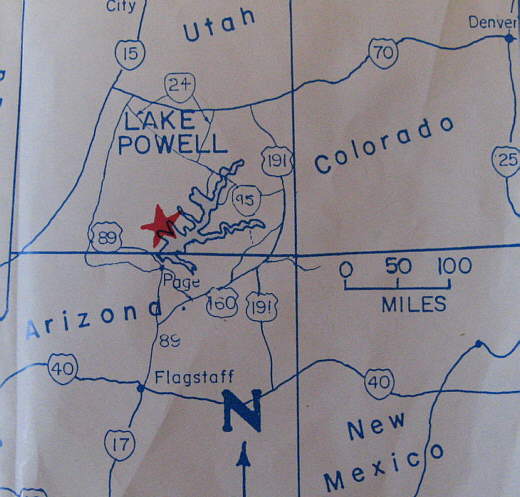
Ruth and I bought a 1990 MacGregor 26S in January 2009 and commenced to work on it with numerous modifications that we felt would make the boat 'ours' and one that would let us explore the world in a very new way for us. Our nearest lake of any size is Lake Powell about 90 miles west of our high desert home in Blanding, Utah.
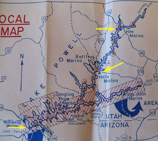
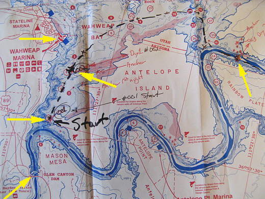
.............(This and all the other photos of the maps that show our daily progress are from FISH-n-MAP CO and are the Lake Powell South and Lake Powell North maps. We purchased them on the Internet. We saw them for sale on the lake at Dangling Rope Marina, but I wouldn't take a chance and would get these two maps before going to the lake. You really need them.)
On reading of other's trips to Lake Powell it became apparent that most go there for the extraordinary canyon country scenery that is unlike any other place in the U.S.. Actually sailing was something that was second and was often stated as very hard to do in the narrow canyons that capture the lake's water. This results in most sailors spending much of their time at Lake Powell running under power and not sailing. This is very understandable as most sailboat owners that visit the lake are probably on vacation where time is important and they want to see as much of the scenery as time will permit.
........
We started thinking that it might be a real accomplishment on our part if we could actually sail the length of the lake from the dam at Page (lower left arrow), up past the ferry at Bullfrog/Halls Crossing (middle arrow) and on to Hite (top arrow). Only using a motor to reach an anchorage or place to tie ashore for the night. Returning the next day to exactly where we had stopped sailing and continuing on up the lake only under sail. We wondered if anyone had actually ever done this and still do. If someone has we would like to hear from them. If no one else has accomplished this journey, then maybe our journey down the lake will prompt others to try the same thing.
With all of that being said we hope you follow along with us as we try to sail the length of Lake Powell experiencing with us a trip that had a lot of good moments to remember and some not so good moments. Regardless, it was a trip we will remember the rest of our lives and be proud that we took in spite of the outcome.
A few facts about Lake Powell. It is one of the largest man-made lakes in the world and the second largest in the United States, with only Lake Mead the next lake down the Colorado being larger. It is about 180 miles long at 'full pool' and has over 2,200 miles of shoreline, more than the U.S. Pacific Coast. It is a big lake and can be a dangerous one (see day 12 of this journal).
Night's Anchorage: South side of Wahweap Bay a couple miles above the dam at Page, AZ.
( N. 36o 58.010' -- W. 111o 28.339' ) Sailed about 0 miles -- motored about 1 1/2 miles
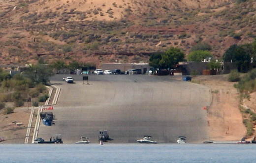
We left Blanding around 9:30 a.m. and drove 195 miles to Page, AZ with our good friends Shawn and his brother Alex. After a quick lunch in Page we got to the boat ramp at Wahweap Marina around 2:30. The ramp and other facilities are operated by ARAMARK, the park concessionaire, with Lake Powell being located in Glen Canyon National Recreational Area administered by the U.S. National Park Service.
We launched a little before 4:30 p.m., a new record for us, but Shawn's and Alex's help was partially responsible for that. This was the ..............
........
..........the largest and busiest ramp we had been to yet. The ramp is over 100 yards wide with nice docks on each side. People were launching and retrieving all the way across its width. Lake Powell has Zebra Mussel inspections, but at the park gate they asked what lake we had been on last and we told them Lake Powell, which we had been on for 3 days the first of September. Since we hadn't been on a "bad zebra infested lake" in the previous 30 days they filled out paperwork to be displayed on our dash and didn't send us to the inspection area.
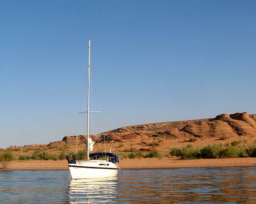
After launching with no problems we said our good-byes to Shawn and Alex and as we headed off out into the lake they disappeared up the ramp with the Suburban and trailer. We were now committed to our plan of trying to sail from near the dam, at Page, the length of the lake to Hite at the far north end of the lake where the Colorado River enters the lake about 150 miles away. Probably an unrealistic expectation, but we were going to try.
We wanted to motor down the lake about 1 mile above the dam and start there at the southwest side of Antelope Island just above the dam.
........
About 1/2 mile short of that destination we anchored in 10 feet of water with a sand bottom in a side bay of Wahweap Bay. We were tired and dehydrated as the temperature was in the mid 90's and we hadn't been drinking enough. While eating a quick supper of pasta and peaches we realize we had set off without loading our bread for the trip and once past the marina here there was only the marina at Dangling Rope and we didn't know what to expect there as that marina is only serviced by water as there is no road to it. The lack of bread was not good as we had a lot of cheese and sandwich meat for sandwiches. We decided to stick with our plan and sail up the lake and when we went back past the marina at Wahweap to stop and see if they had bread at the store there.
There was also one other problem. We didn't know if we could sail that way with the lake as low as it was as we wouldn't be in the main channel as it went up the south side of Antelope Island. If the water is high enough the channel that goes around the north side of Antelope past the marina rejoins the main channel again on the northeast side of Antelope Island.
So hopefully with some wind on Sunday we would get back to the marina for bread and then continue up the lake and on around the island if there was deep enough water in that direction to do so.
........
This map is from the dam (lower left arrow) up to our second days stopping point (far right arrow). We put in at Wahweap Marina (top left arrow) and spent the first night right under the middle arrow and the second night right above the middle arrow. The middle arrow on the left is where we decided to start the journey a little over a mile up from the dam where you can (if the lake level is high enough) go either around Antelope Island to the south in what was the Colorado River channel or up to the left of the island past the marina and then off to the east and is the route we took (see dotted line). The middle arrow just to the right of the three left arrow is all the further we got the first day and there will be a more detailed map on the next page.